
The Planning Project Showcase includes examples of projects involving urban planning students, including planning workshops, applied projects and thesis work.
MUEP Planning Workshop
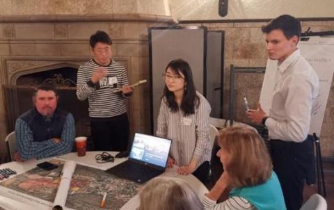
One of the culminating experience options for students in the Master of Urban and Environmental Planning (MUEP) program is PUP 580 - Planning Workshop. The workshop immerses students in a real-world planning context to provide an integrative academic and professional experience.
Working as a team, students define the problem scope and apply appropriate methodologies to identify a solution or recommendations.
The final products for the course typically consist of a professional report and presentation. Read more about our past workshops:
MUEP Thesis and Applied Projects
Students in the Master of Urban and Environmental Planning (MUEP) program also have the option to complete an individualized project as their culminating experience. They can choose to participate in PUP 593 Applied Project or PUP 599 Master’s Thesis.
The master’s thesis is an extensive piece of original research that demonstrates the capability of the student to act as an independent scholar.
The applied project involves the application of advanced planning methodologies to a specific, real-world planning problem and is prepared for a planning-related organization (the client).
Please feel free to explore the below projects to learn more about the work of our students:
Projects from the Class of 2020
Hannah Trostle - 2020 Spring Graduate
This project is the first step toward a regional plan in the Navajo Nation: It consisted of a report on the Visioning Workshop and recommendations for next steps. The Chapters that comprise District 6 have been considering regional approaches to addressing some of the issues in their communities. The Visioning Workshop gave the leadership of the Chapters the opportunity to discuss these issues in-depth and develop a shared solution. The Visioning Workshop used best practices to develop vision statements and then participants went into a SWOT analysis.The report analyzed the qualitative data from the workshop, outlining the overall experience and highlighting how their ideas could be implemented going forward. The results were driven by the ideas presented at the the end of the Visioning Workshop.
Contact information
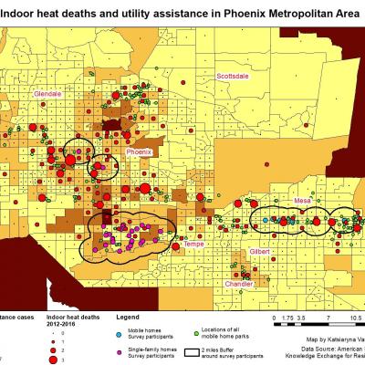
Katsiaryna Varfalameyeva - 2020 Spring Graduate
This project was done for the Knowledge Exchange for Resilience, ASU.
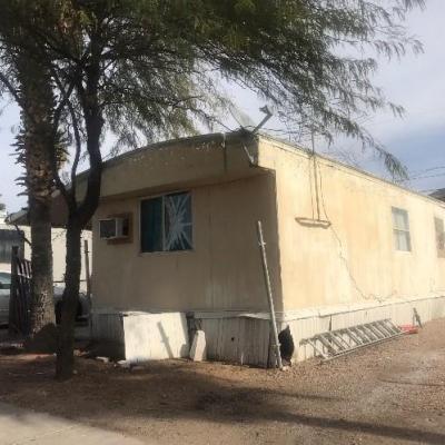
Mobile homes play a vital role in the housing market in Arizona and the USA in general being one of the most affordable types of housing options. Most of the time, the affordability of this type of housing is based on cheaper low-quality construction which results in significantly lower pricing than single-family homes. However, low-quality construction has poor insulation that results in a higher amount of energy to cool down a house during the summer. Therefore, the affordability of mobile homes transfers into hidden expenses like higher utility bills. The issue of higher utility bills from mobile home ownership is crucial in Arizona because of the high temperatures in summer. Heat exposure results in high numbers of heat morbidities and heat deaths. Specifically, in Maricopa County, more than one-third of heat deaths happen inside, and more than a quarter of those occur in mobile homes. The goal of this project is to analyze the relationships between mobile homes and heat-related morbidities\mortalities and to evaluate what economic role heat exposure plays for the affordability of mobile housing in the Phoenix Metropolitan Area.
The methodology of this project is based on the comparison of mobile homes and single-family homes through complex analysis. The study showed that the affordability of mobile homes, which is based on low-quality construction, makes their residents vulnerable to heat exposure. Survey analysis showed that more than one-third of the mobile home population has to spend more than 10% of their monthly income just for electricity, while for some this percentage can reach 30-50% of their entire budget in summer. It is a significant percentage as more than half of the mobile home population has income less than $25,000 per year. In contrast, single-family home residents pay less than 10% of their monthly income just for electricity. Other negative consequences have been revealed from the heat exposure that includes medical symptoms and change of lifestyle in the pursuit of savings.
Contact information
Brian Peck - 2020 Spring Graduate
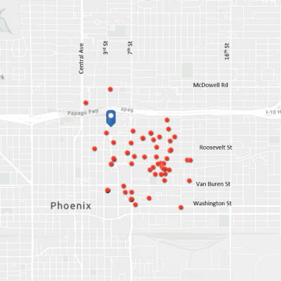
The City of Phoenix is one of the most dangerous places in America to be a pedestrian. ASU has entered into an agreement with the City to research pedestrian crashes and find potential causes and mitigation measures to reduce this phenomenon. This project included a logistic regression to try and interpret the variables associated with a higher degree of risk for pedestrian versus automobile collisions. After a year of data cleaning and analysis, a report was produced which explains to the City our findings from the model and subsequent suggestions on how to improve pedestrian safety based on our findings.
Contact information
Chloe Durfee-Sherman - 2020 Spring Graduate
This project presents the results of one part of a multifaceted pedestrian safety analysis being conducted for the City of Phoenix with a goal of having a better understanding of why pedestrian crashes are happening where they are as well as increasing pedestrian safety on the streets throughout the city. It includes two studies that used qualitative analysis to examine how crashes were associated with built environment factors and surrounding land uses. These studies showed that intersections that lack the presence of pedestrian signals and have sidewalks that are less than five feet wide are more likely to see severe crashes while it also suggests that the presence of apartment complexes, restaurants, and convenience stores may not only be more likely to coincide with an increase of pedestrian crashes but also with an increase of severe crashes, especially in clusters.
To take advantage of the information presented in this project, it is recommended that the City of Phoenix take a number of steps to help increase pedestrian safety throughout the city. One suggested step would be to make sure that when future sidewalk updates and installations are done, sidewalks under five feet are increased to be at least five feet wide. This could also be done by creating new guidelines for setbacks so that sidewalks can be a minimum of five feet. Another suggested step for the city would be to install more signalized pedestrian crossings in areas with apartment complexes, restaurants, and convenience stores, which have shown to be high-risk areas for pedestrians. The city should also take steps to further study intersections with high volumes of crashes, especially high volumes of severe crashes, with the use of cameras to better understand and address pedestrian safety in these areas.
Contact information
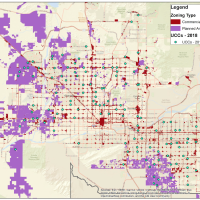
Kevin Carranza - 2020 Spring Graduate
This project was an overview of Urgent Care Centers (UCCs) generally -- their growth and their evolving role in the spectrum of healthcare -- as well as a detailed look at UCCs in Maricopa County. The client was Equality Health, a local integrated healthcare delivery system who, because they work with and own many provider types, was interested data on UCC growth, location trends, and procedure trends. The project sought to answer Equality Health's questions and also consider UCCs from a planning and zoning perspective: how have cities and their residents addressed UCCs, if at all?
The project used literature review, GIS, headline searches, and a few spatial statistical tools to try to furnish answers to the above questions. Ultimately, results indicated that UCCs in Maricopa County locate simply where there are more people, rather than target certain groups (like those with private insurance) or avoid others (like those with Medicaid insurance). It also found that, among Medicare patients, slightly less than 1 in 10 procedures billed by a UCC were among the services most commonly performed by Arizona primary care providers, which suggests that some Medicare patients may be using UCCs as a stand-in for primary care. The report found that some cities and states are addressing UCCs in their municipal code and statutes; the project concludes with a handful of recommendations for public entities. These include, at the state level, considering ways to integrate UCCs into healthcare networks, and at the city level, defining UCCs in the zoning code and potentially reviewing all health care uses (including UCCs) to keep land use policies up to date with a changing healthcare landscape.
Contact information
Michael Schwartz - 2020 Spring Graduate
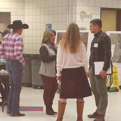
The purpose of the Camp Verde Urban Upland Trail Plan is to serve as an inventory and analysis of existing trailheads, trails, urban routes, and anchor sites. The inventory can then be proposed adopted as an amendment to the town of Camp Verde 2016 General Plan by the town council. The document can then be used to facilitate and prioritize the development of the system-wide network in greater Camp Verde. Consultation with the town of Camp Verde Economic Development Department, Community Planning Department, and a 12-member steering committee informed the Urban Upland Trail Plan. TThe plan extents consist of two adjacent National Forest lands and multiple recreation site connections throughout the town and its periphery. The methodology included inventory, mapping, design standards, phasing, and cost estimates. Presented maps at a public meeting to over 50 members of the public and engaged in qualitative data collection for community vision of the Trail Plan. The plan was then drafted to client specifications. Currently, the planning document is undergoing revisions, imagery selection, and presentation development for delivery to the town council.
Contact information
Kelly Bitler - 2020 Spring Graduate
This project is a mapping exercise to explore diversity and social context of a historic Phoenix synagogue in 1940 which focuses on the intersection of geography, urban planning, history, and culture. It was completed in support of the cross-disciplinary Beth Hebrew Research Team, which seeks to explore the past of Beth Hebrew Synagogue, located in downtown Phoenix. The building was home to first a Jewish congregation, then a Latino Protestant congregation, and finally the Black Theatre Troupe before being abandoned. Now, it is hoped that with the information collected by the research team, it may become a place of community gathering and education.
The first component of the project was reviewing 1940 census data for race, country of origin, and addresses. This information was used to create maps of Hispanic and Black populations living in the area to answer questions about the community Beth Hebrew was created in. Was it diverse? Were Jewish people treated as a minority to some degree? How did the practice of redlining affect this area? The information collected was then mapped to be included as a graphic in an article for a local journal written by Dr. Volker Benkert of the School of Historical, Philosophical, and Religious Studies. We found that the area was more diverse than many other Phoenix communities, with a relatively strong Hispanic presence due in part to the proximity of St. Mary's Basilica.
Contact information
Jonathan Garrett - 2020 Spring Graduate
Since its inception in 1991, the Americans with Disabilities Act and the United States Access Board have helped create a more equitable public realm by developing design standards for public infrastructure and enforcing compliance. This has increased opportunity for, and participation of, people with disabilities at places of work, school, and beyond. On the other hand, it has also made clear there is still much work to do. The laws and standards that currently govern accessible design and other accommodations are seen as a failure to many people with disabilities as they have not torn down the “wall of exclusion” (Kanter, 2015).
To combat this “failure”, this project, completed for Stantec Consulting, Inc., has developed an Accessibility Audit Tool, informed by literature, user surveys, field work, and pilot tests that collects quantitative and qualitative data pertaining to sidewalks and crosswalks – two critical pieces of infrastructure that have a great impact on the mobility of many people with disabilities. The project sought to 1) support crowdsourced data input; and 2) define inputs and criteria that seek to optimize the user experience beyond ADA minimum design standards. The result is a Microsoft Excel spreadsheet that a user can access via the Excel mobile application or a printed version to start collecting street data anywhere at any time. It includes an infrastructure rubric to help people consistently rate the more qualitative measures required for evaluation as well as instructions for how to collect the data. In a later phase of this project, the audit tool will be validated by users, in particular, people with disabilities. Input categories and criteria will also be expanded. Lastly, the audit tool will take the form of a dedicated accessible mobile application for iOS and Android that stores collected data for research team retrieval and future analysis.
Contact information
Yousuf Mahid - 2020 Spring Graduate
Deforestation is a common phenomenon in Bangladesh, leaving the country under a great threat of losing its natural habitat. The increasing rate of natural habitat loss has raised questions regarding the country’s forest resource management practices. These practices were originally adopted to protect the forest ecosystem and secure the livelihood of the people dependent on forest resources. Despite the support from development partners like the United States Agency for International Development (USAID), the country is still struggling to protect its forest resources from human encroachment. One of the major problems is the lack of inconclusiveness in current approaches. Most initiatives are not evidence-based and are project-based for only a certain period of time. This has failed to ensure sustainable outcomes. This study looks at Bangladesh’s Himchari National Park forest management system to generate evidence regarding deforestation from 1991-2018 and highlight existing gaps. To identify and analyze the gaps, the study uses a social-ecological system (SES) lens. Results reveal deforestation across different time periods, articulates the overall governance structure regarding forest resource management and provides an overview of the major gaps within the system. The study also offers a set of recommendations for improving the existing management system and policy implications.
Contact information
Mastura Safayet - 2020 Fall Graduate
Disparities in access to healthy food are a key public health concern in the United States (U.S.). Food access is considered as a critical element of food insecurity. Food insecurity can often be prevalent in a region due to a lack of healthy food outlets as well as inequitable access to healthy food outlets. A large body of literature pertaining to access to healthy food has reported that conventional food outlets such as supermarkets and large grocery stores may not be equitably distributed across different neighborhoods in a region. There has been limited research on local food access patterns. Despite the few studies focused on access to individual types of local food outlets, such as farmers markets, little is known about whether such access varies among different types of local food outlets and how such access patterns compare with the uneven access to conventional food outlets. This study uses Maricopa County, one of the largest counties in Arizona, as a case study to examine the spatial patterns of access to conventional food markets (i.e. supermarkets or large grocery stores) and four different types of local food outlets, including farmers market, community garden, community-supported agriculture (CSA) and mobile food markets. By analyzing the association between healthy food access and neighborhood characteristics, the study suggests that the local food system has a great potential in providing healthy food access to low-income and minority populations of the County than conventional food outlets. The study provides important insights into the way different types of local food outlets offer their availability in space and whether they are more equitable in serving underserved neighborhoods. The findings from this study can assist both government agencies and city planner formulate strategies to improve access to healthy food in disadvantaged neighborhoods.
Contact information
Projects from the Class of 2019
Maggie Dellow - 2019 Spring Graduate
Over the Spring on 2019, I worked with the City of Apache Junction to complete an assessment of mobile home and RV parks as well as affordable housing opportunities. Over 50% of the City of Apache Junction’s housing stock is composed of mobile, manufactured and RV homes. Of the estimated 125 mobile home and RV park communities in Apache Junction, a significant number are in advanced stages of dilapidation. Many of the most challenged parks predate the city itself, failing to conform to current city zoning code and lacking modern infrastructure. For many of these non-conforming mobile home and RV parks, the housing stock is just as outdated, some of which was built and established prior to the U.S. Department of Housing and Urban Development’s (HUD) National Manufactured Housing Construction and Safety Standards Act of 1974, failing to meet federal standards for quality, durability and safety. Additionally, many of the communities in question pose health and safety risks in general, violating city code in terms of property maintenance, building codes and refuse and garbage removal. To preserve property owner interests and the affordable housing stock that is made possible through mobile housing, the City granted properties “rights of lawful non-conformance” which allows them to continue operating their property in its current fashion. However, as property values rise and the cost of making necessary improvements increases, mobile home parks become vulnerable to closure, and their residents, victim to displacement.
The goals of this project were threefold: 1) Improve the conditions of high-priority parks and increase the quality of living for residents; 2) Promote the redevelopment of parks into alternative affordable housing units when appropriate; and 3) Preserve affordable housing to meet the demonstrated need of the Apache Junction’s population. Through a series of tasks, including a literature review, needs assessment of properties, and semi-structured interviews with stakeholders, I developed research findings and analysis that identified the following five main recommendations and ideas for implementation:
- Develop a strategy for preservation, improvement, and promotion of redevelopment.
- Support and invest in mobile home and RV park owners.
- Be proactive in attracting and incentivizing developers to pursue affordable and market-rate housing development in the City.
- Create an action protocol for when owners list mobile home and RV parks for sale.
- Create an affordable housing development overlay district.
Contact information
Projects from the Class of 2018
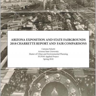
Catyana Falsetti - 2018 Fall Graduate
The Arizona Exposition and State Fair (AESF) hosts a Fall event that occupies the grounds for 24 days during October and/or November. The fair is popular with over 1,145,503 attendees in 2016 (Final Report, 2016), but there are unique challenges to amplify the usage of the Fairgrounds during the remaining months of the year.
AESF would like to increase concurrent experiences, expand the number of hosted events during the summer months, and over more activities during the week. A critical usage constraint is the positioning of the buildings within the boundary of the grounds. The buildings are
primarily clustered towards the southern and western edges of the property, which makes directed accessibility to all buildings simultaneously awkward for vendors.
AESF, the State Historic Preservation Oce (SHPO), and Arizona State University (ASU) facilitated a four- day charrette in March 2018 to address various concerns regarding the use of the Fairgrounds and to generate solutions. Attendees included local and state politicians, SHPO personnel, AESF representatives, and ASU faculty, along with local architects, landscape designers, neighborhood residents, and real estate developers. This four-day charrette and case study comparisons of
the Texas State Fair and EXPO New Mexico introduce approaches to overcome policy and design limitations that have inhibited the Arizona Fairgrounds to date.
The results of the charrette and supplementary research findings elucidate significant barriers due to the current funding structure and the state-imposed legislative limits on capital investments and operational funding. Typically, the AESF is authorized to use approximately $12 million in operating costs and $1 million on capital improvements. The agency retains monies generated that exceed the authorized amount and often are swept by the legislature. The budget amount does not take the cost of inaction or other factors into consideration, including the raise in the minimum wage. The inability of AESF to spend more leaves AESF unable to initiate and complete the improvements required for simple upkeep such as properly maintained air-conditioning units, paint, and roof conservation. Is the lack of accessible funds and spending authority is the key factor in the current aesthetic state of the buildings and grounds. AESF highlighted several design concerns including lack of visual interest of the Fairgrounds from the road, general aesthetics, and comfort of the Fairgrounds, and accessibility of different venues from the street so as not to interfere with simultaneous events. Other recommendations embraced allowing concomitant events that would generate more income from space rental.
Contact information
Projects from the Class of 2017
Jinwen Xu - 2017 Fall Graduate
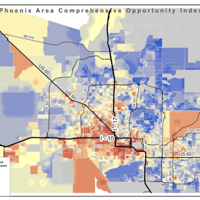
The research derived parameters from various criterions in fair housing and used ArcGIS model builder to combine them into a comprehensive model. Five major categories for these parameters are education, economy, housing, transportation, and health care. The weighed sum of these parameters is calculated to show fair housing index in block groups respectively. The research also analyzes on the relationship between opportunity index and city establishment which turns out that areas with long history tend to have less housing opportunity than newly established regions.
This project was created and started because of the Southwest Fair Housing Council’s (SWFHC) goal to fight for equal access housing for everyone. With a research project for the Phoenix Area the SWFHC would have research to back any claims that may be filed with them on unfair housing. This project provides research on areas needing outreach or advocacy. Another goal of this project is to analyze any correlations between access to opportunity and race and ethnicity in the Phoenix Area.
Contact information
Genevieve Pearthree - 2017 Spring Graduate
This research is the first comprehensive assessment of long-term housing affordability and population trends in the small mountain resort community of Ketchum, Idaho. It examined the effects of short-term and vacation rentals on affordable housing, as well as long-term housing affordability, focusing on areas the City of Ketchum believed could be the most illuminating: 1) long-term housing and demographic trends using U.S. Census data; 2) strengths and weaknesses of Ketchum’s housing affordability and short-term rental policies; 3) relevant Idaho state statutes and court cases; 4) case studies of other resort communities; 5) potential policies to address housing unaffordability and regulate short-term rentals; and 6) specific changes most likely to grow workforce housing. Key findings confirmed that vacation and short-term rentals in Ketchum, and the surrounding region, appear to raise overall housing prices while removing affordable properties from the housing market, leading to housing scarcity and increasingly high housing prices over time.
This research generated several policy recommendations to address the supply and affordability of housing, including incentivizing long-term rentals, tracking the short-term rental market over time, and changing zoning and regulatory ordinances to grow the workforce housing supply. The City of Ketchum has shared the research findings with city governments across the state of Idaho, many of which also struggle with housing affordability and regulation of short-term rentals. The research appears to have jump-started conversations about housing affordability and short-term rentals across a broad swath of Ketchum’s community, including policymakers, realtors, and Ketchum’s working residents.
Contact information